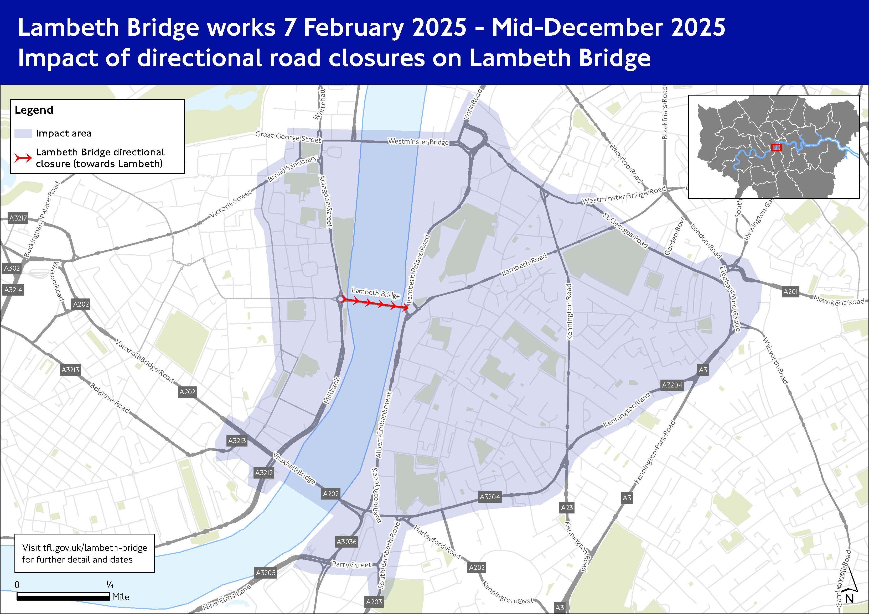
Lambeth Bridge works
We are replacing the roundabouts at both ends of Lambeth Bridge with traffic lights. This is to improve safety in the area, particularly for people cycling.
Find out more about this project.
We need to carry out a series of closures of the bridge between Thursday 30 January and Monday 15 December 2025.
These will include full closures and closures only in one direction.
Planned closures
Thursday 30 January - Friday 7 February
- Overnight full closures
- Lambeth Bridge will be closed to all vehicles (including people cycling) each night 21:30-05:00
- People will be able to walk across the bridge
Friday 7 - Monday 10 February
- Full bridge closure, day and night
- Lambeth Bridge will be closed to all vehicles (including people cycling)
- People will be able to walk across the bridge
05:00 Monday 10 February - Friday 18 July
- Closure in one direction
- Lambeth Bridge will be closed day and night to motorised vehicles heading south of the river (Westminster to Lambeth)
- Traffic heading the other way will be unaffected
- People will be able to walk and cycle across the bridge
Friday 18 July - Monday 21 July
- Full bridge closure, day and night
- Lambeth Bridge will be closed to all vehicles (including people cycling)
- People will be able to walk across the bridge
Monday 21 July - Monday 15 December
- Closure in one direction
- Lambeth Bridge will be closed day and night to motorised vehicles heading south of the river (Westminster to Lambeth)
- Traffic heading the other way will be unaffected
- People will be able to walk and cycle across the bridge
Traffic impact
Driving
- Plan ahead and travel during at quieter times
- Check our status updates for roads
- Use alternative river crossings where possible, whichever way you are crossing the river
- There will be clearly signed diversion routes across Vauxhall Bridge and Westminster Bridge during the works
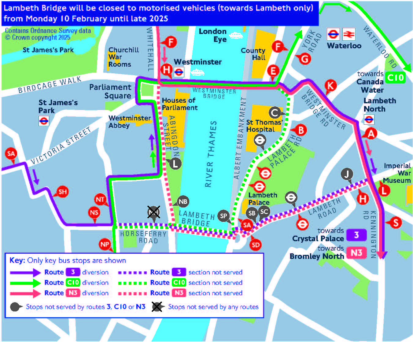
Bus
Buses using Lambeth Bridge
Routes 3, N3 and C10 will be diverted via Westminster Bridge.
- During full closures, all buses will be diverted
- During part closures, only buses heading south of the river (travelling from Westminster to Lambeth) will be diverted
Bus route 3 towards Crystal Palace (during directional closure only)
This route will be diverted via Marsham Street (serving stop NT), Great Peter Street, Abingdon Street, St Margaret Street, Parliament Square, Bridge Street (serving stop H), Westminster Bridge, Westminster Bridge Road (serving stops E for St Thomas' Hospital and K) and Kennington Road (serving stop A).
- Route 3 towards Crystal Palace will not serve stop NH on Horseferry Road, which will close temporarily
- For stop NH on Horseferry Road - get off route 3 at stop NS on Horseferry Road,
- Routes 3 towards Crystal Palace will not serve stops on Lambeth Road
- For Lambeth Road - use diverted route 3 to Kennington Road / Imperial War Museum and alight at stop S. Walk to stop L on Lambeth Road and use route 344 (24-hour)
- Alternatively, walk across Lambeth Bridge and use route 344 from stop SC
Bus route C10 towards Canada Water (during directional closure only)
This route will be diverted via Marsham Street (serving stop NT), Great Peter Street, Abingdon Street, St Margaret Street, Parliament Square, Bridge Street (serving stop H), Westminster Bridge and Westminster Bridge Road (serving stop E for St Thomas' Hospital).
- Route C10 towards Canada Water will not serve stop NH on Horseferry Road, which will close temporarily
- For stop NH on Horseferry Road - get off route C10 at stop NP on Marsham Street
- Route C10 towards Canada Water will not serve Lambeth Palace Road
- For St Thomas' Hospital - use diverted route C10 and alight at stop E at County Hall / St Thomas Hospital
- For Lambeth Palace Road - use diverted route C10 and alight at stop F on York Road. Use the crossing and walk to stop G for route 77 to stops on Lambeth Palace Road. Take care crossing the road
- Alternatively, walk across Lambeth Bridge and use route 77
Bus route N3 towards Bromley North (during directional closure only)
This route will be diverted via Bridge Street (serving stop H), Westminster Bridge, Westminster Bridge Road (serving stops E for St Thomas' Hospital and K) and Kennington Road (serving stop A)
- Route N3 towards Bromley North will not serve Abingdon Road or Millbank
- For stops L on Abingdon Road or NB on Millbank - use route N87 from Trafalgar Square. Alternatively, change from route N3 to N87 at stop F at Westminster station
- Route N3 towards Bromley North will not serve stops on Lambeth Road
- For Lambeth Road - use diverted route N3 to Kennington Road / Imperial War Museum and alight at stop S. Walk to stop L on Lambeth Road and use route 344 (24-hour)
- Alternatively, walk across Lambeth Bridge and use route 344 from stop SC
Other buses in the area
Other buses on the Westminster side of the river will be affected by increased levels of traffic. Journeys may take longer than usual.
These routes are likely to be affected: 87, N87, 77, 344
On the Lambeth side, bus routes will be less affected during part-closures.
Cycling
Full closures and overnight closures
- You will not be able to cycle across the bridge
- Use alternative river crossings where possible
- There will be clearly signed diversion routes using cycle lanes separated from traffic across Vauxhall Bridge and Westminster Bridge
Closures in one direction
You will be able to cycle across the bridge in either direction.
- Heading south of the river (Westminster to Lambeth) - there will be a segregated cycle lane
- Heading north of the river (Lambeth to Westminster) - you need to cycle with the flow of traffic
Walking
All closures
- You will be able to walk across the bridge
- One pavement will be open throughout the works
Use our travel tools
Check before you travel and plan ahead using our travel tools. To keep up-to-date with the latest service information, see:
- The latest status updates for buses and traffic
- The latest status updates for Tube, rail and trams
- The TfL Go app and Journey Planner, which can help you plan your route by public transport, cycling or walking
- Nearby, which uses your current location or a postcode or address of your choice and places you on a map, showing you Tube, bus, rail and Santander Cycles locations around you
- Our email updates